Meghry is one of the ancient dwellings of
Armenia. Its area was inhabited since the prehistoric times.
The Bronze Ages common swords, bracelets, necklaces, iron knives
and other things were found in the town (the 7th-6th centuries
BC). In the BC 6TH c Meghry and the surrounded area belonged
to the Artashesyan Armenian United Kingdom as a land of Syunyats
ministerial line. The area coincides with the province of Syunyats
Arevik, which was famous for its developed vine-growing. In
428 Arevik fell under the domination of Sasanian Iran and in
640 it was conquered by the Arabs. In 886 it was included in
the Bagratunyats kingdom and in the beginning of 980 it was
included in the kingdom of Syunik. In 906 after the Tatev monastery
had been built Meghry was called Karchavan by Smbat Bagratuny.
During the reign of Syunyats Grigor B king in 1105 the Seljuk-Turks
conquered Meghry. In 1126 Amir-Haron Amira’s attackers
organized a genocide in Meghry.
Since the beginning of the 13th century Meghry was included
in the territory of Zakaryan Armenia as a land of the Orbelyan
line. Later it fell under the domination of Mongol-Turks and
Sefyan Iran.
In 1603 the population was forcibly emigrated
to the province of Spahan. In 1805 the town and the district
of Meghry was jointed to Russia. In 1828 it was included in
the province of Karabagh. In 1868 Meghry was a part of Zangezour
province of Elizavetpol state. After the establishment of the
Soviet rules until 1930 it was called Meghry province. In September
9, 1930 the region of Meghry was formed with the center of Meghry.
Meghry was well-known of its agriculture,
pottery, fruit-growing, silk culture, etc. In the end of the
previous century it was regarded as one of the developed placed
in Trans-Caucasus. Matevos Shahyan, a Meghry man on his way
from Karabagh to Tiphlis sheltered in Meghry and in 1881 opened
a parish school with the support of well-known Armenian Writer
Raffy. In 1901 the first consumer cooperative of Armenia was
organized in Meghry. The first was brought here. People carried
the piano on their shoulders from Ordubad to Meghry (40 km).
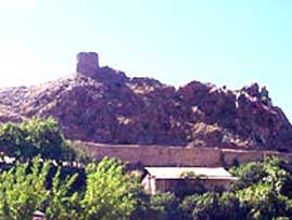
St. Astvatsatsin (17th century), St. Hovhannes (17th century),
St. Sargis (17th century) churches, the monastery of Anapastanats
(11th century) and the fortress of Meghry are the historical
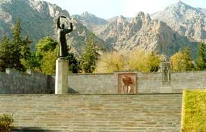
architectural monuments of Meghry. There are tombs with khachkars
in the town and in its surroundings. In 1950 the first plan
of the town was confirmed by the architecture H. Davtyan. In
1972 the second plan was confirmed by V. Morzoyan, G. Gyurjyan
and G. Sakhudyan.