| |
|
| From
the regional center: |
25
km |
| From
Yerevan: |
356
km |
| Administrative
land area: |
274 ha |
| Height
marks: |
1950
m |
|
Population |
8800 |
|
Date of getting the status of a town: |
1992
|
|
|
| |
|
Geographical Position and Climate |
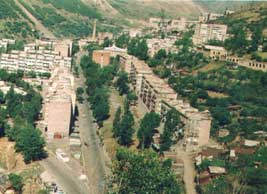
Kadjaran is situated on the upper part of
the river Vogchi and is surrounded by Zangezour and Megri mountain
ranges. The Kadjaran (3403m) and the Kapoutdjugh (3904) mountain-peaks
are to the west of the town.
The climate is dry. It is cold in winter with a thick snow-cover
and cool in summer.
|
|
| |
|
Historical Glimpse of Kadjaran |
The area of Kadjaran has been a dwelling
since the 3rd-2nd millenaries(BC).The pagan Chapel found in
the town’s surrounding testifies that .Since the Bronze
Age here metal has been processed.
Since the beginning of 1840 in the result of researches in
1850 the first copper mines were built which worked till 1910.
In the result of another researches in 1930 the huge copper
mine was found. For the purpose of its manufacturing the Kadjaran
coal-mining factory was built in 1952.It was one of the huge
enterprises of the USSR, which conditions the foundation and
development of Kadjaran. The town was built in the area of Kadjarans,
Verin Hand and Okhchi villages. The majority of the population
of Kadjaran is immigrants from Kapan and Karabakh.
|
|
| |
| Education
, Culture, Health |
|
There are five secondary schools in Kadjaran.
The number of the students is 1341(2001). Four kindergartens,
a cultural center , two clubs, six libraries. There are also a
stadium and a drill-ground. Among the health care organizations
are “The Kadjaran hospital” “ The policlinic
of Kadjaran”, “The stomatological policlinics”. |
|
| |
| Economics |
| Kadjaran is a town of miners. The main branch of the economics
is the branch of the non-ferrous metallurgy. The leader of the industry
is “The Zangezour Coal-mining plant” CJSC, which is
regarded as one of the great industrial centers is Armenia. Not
far from the town the coal huge mine is situated. There are also
sources of mineral water in the territory. |
|